Archaeologists spent more than a century looking for it. They walked the marshy stretches of the western Peloponnese, scanned old maps, and debated lines of ancient text over coffee. Most people figured the swamp had eaten the evidence for good. They were wrong.
The recent excavation of the long-lost Sanctuary of Samian Poseidon near Kato Samiko reveals something much larger than a routine ancient find. This is the rediscovery of a major regional nerve center that shaped Greek identity and politics for centuries. If you think ancient history is static, this discovery proves how wrong that assumption is. Earth shifts. Water moves. Sometimes, it hides a massive temple right under our feet.
The Century Long Hunt for Samikon
The ancient geographer Strabo wrote about this place in his classic text, Geographika. He described a highly revered sanctuary of the Samian Poseidon sitting right in a sacred grove packed with wild olive trees. He noted it sat near the sea below the fortress of Samikon. For decades, researchers treated his descriptions like a treasure map, but the geography refused to cooperate.
What Strabo saw in the first century AD was not what modern explorers encountered. Over two millennia, the coastline moved. Silt accumulated. The low-lying terrain behind the coast transformed into a complex network of lagoons and thick marshland. The Kaiafa swamps basically swallowed the structural remains.
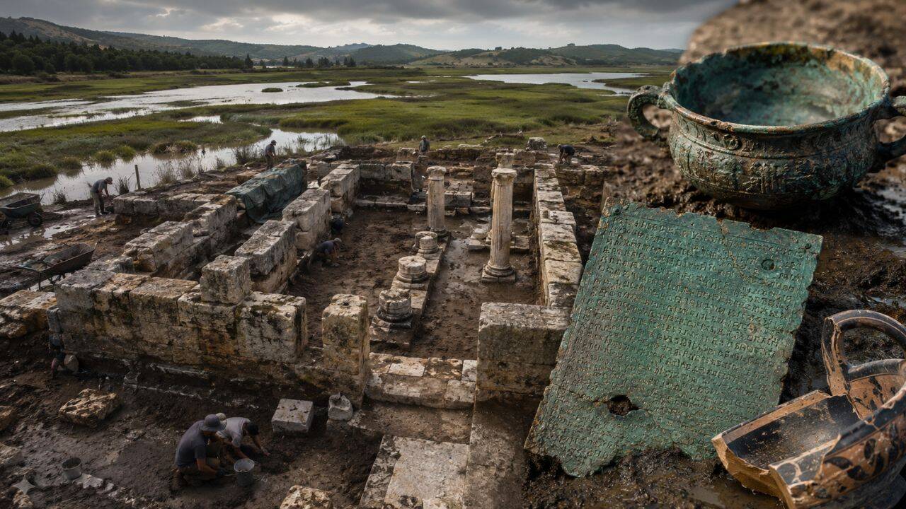
Early in the 20th century, the famous German architect and archaeologist Wilhelm Dörpfeld found a massive double-shelled stone wall in the area. He suspected it had something to do with the sanctuary. He could not prove it. The water was too deep, the mud too thick, and the technology of his era too limited. The site remained hidden until a joint team from the Austrian Archaeological Institute and the Ephorate of Antiquities of Elis joined forces with geophysicists from Kiel and geoarchaeologists from Mainz.
They did not just dig blindly. They used magnetic gradiometry and electrical resistivity tomography to pierce through the swampy deposits. In 2021, the sensors flared. They found the clear footprint of a monumental structure. By 2026, systematic excavations had completely uncovered the building, proving that Dörpfeld's mysterious wall was actually a massive protective dam designed to shield the sacred precinct from lagoon floods.
Inside the Archaic Double Temple
The building is huge. It measures exactly 28 meters long and nearly 9.5 meters wide. Those dimensions do not sound massive by modern stadium standards, but for a 6th-century BC structure built on unstable marshy ground, it is a staggering engineering feat. The foundations rest on a bed of sand embedded directly within lagoonal muck.
The architecture itself breaks the standard mold. Most ancient Greek temples follow a predictable, symmetrical layout with a single central room for the deity. This one is an archaic double temple. It features two large interior halls aligned along an axis, with central pillars supporting a heavy roof. Each side boasts a separate vestibule with columns.
Why build a double temple? Archaeologists are currently debating two main ideas.
The first option is religious. The temple might have served two distinct deities. While Poseidon was the primary master of the house, the second hall could have belonged to another god or local hero. The second option is entirely political. The sanctuary was not an isolated rural shrine. It functioned as the religious and ethnic headquarters for the Triphylian cities, a powerful league or confederation of six local settlements including Lepreum, Macistus, and Phrixa.
The twin chambers might have given these different cities equal space to gather, conduct diplomatic business, and worship. It was a communal hall disguised as a house of god.
The Clues Left in Bronze and Iron
Two specific artifacts pulled from the mud confirm exactly what this place was. They also tell us how much the ancients valued it.
First, researchers uncovered a large bronze plaque measuring 40.5 by 27.5 centimeters. It was found sitting in the northwestern hall, likely once affixed to a mud-brick wall before the building collapsed. When it came out of the ground, it was incredibly fragile, requiring extraction inside a solid block of surrounding earth. Initial laboratory work and X-ray imaging revealed a extensive inscription written across its surface. The text explicitly mentions the sanctuary of Poseidon Samios. That single artifact ended a 100-year academic debate. It is the definitive birth certificate of the site.
Second, the team discovered fragments of a massive marble water basin. This type of vessel is known as a perirrhanterion. It has a diameter of about one meter and was used by worshippers for ritual cleansing before entering the sacred spaces. The design itself is beautiful, mimicking a high-end bronze cauldron with intricate handles.
The most interesting detail about this marble basin is its scars. It features ancient repairs held together by heavy iron clamps. Marble was expensive. Shipping it to a marshy coastal plain required serious funding. When the basin cracked, the priests did not throw it away. They drilled into the stone and bound it back together with metal. It tells you that this site had a long history of active, continuous use. They maintained what they had.
How Mud and Water Swallowed History
You cannot understand this temple without understanding the water. Greeks associated Poseidon with the sea, but they also tied him to rivers, springs, and marshes. Placing his sanctuary in a wetland was an intentional choice. It honored his dominion over the unstable elements of the earth.
That same water eventually became the enemy. Geoarchaeological drilling shows that the temple suffered through multiple high-energy flooding events during its lifetime. The natural environment was constantly trying to reclaim the space.
Sometime around 300 BC, or the early 3rd century BC, the community gave up the fight. The structural evidence shows that the site was not leveled by an invading army. Instead, it was systematically abandoned. Workers carefully dismantled the heavy Laconian terracotta roof tiles and stacked them inside the building, covering the original floor. They basically packed the temple away. A dense layer of roof tiles, mixed with charcoal concentrations and burnt mudbrick, suggests a subsequent fire finished off what remained of the standing walls, sealing the artifacts beneath a thick layer of protective debris. Silt and swamp water did the rest.
What This Means for Ancient Greek Politics
We often view ancient Greece as a collection of warring city-states like Athens and Sparta. We forget about the smaller regional alliances that kept the peace in the provinces. The Triphylian league used this temple to project unity.
The people of Macistum were given the prestigious job of managing the sanctuary. They were the ones who officially proclaimed the "Samian" armistice day, a sacred truce that allowed people from all over the region to travel safely through the wetlands to worship. Every city in the confederation chipped in cash to maintain the grounds.
Discoveries like this alter our perspective on early Greek federalism. The sanctuary was an administrative anchor. It controlled a vital coastal passage through the swamps, allowing the league to monitor trade, manage regional defense, and keep the neighboring Eleians at bay.
How to Follow the Discovery
The excavation is part of an ongoing five-year research program running through the late 2020s. The team is still digging, and the conservation work on the bronze plaque has only just begun. Epigraphists are currently translating the full inscription, which will likely reveal names of ancient leaders, specific laws, or details about regional treaties.
If you want to keep tabs on this discovery, stop reading generic summaries. You can check the official research updates directly through the Austrian Archaeological Institute branch in Athens or follow the published reports in the journal Archaeological Prospection. The project coordinates closely with the Ephorate of Antiquities of Elis, which frequently updates its local archive findings. Keep an eye out for the full transcription of the bronze plaque. That text will likely rewrite what we know about the political landscape of the western Peloponnese.


/LouvresengchyeteoGettyImages-5a14669aaad52b00370c599e.jpg)