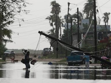
Mother Nature isn't slowing down. Right on the heels of the destruction left by Hurricane Polo, another heavy hitter has entered the chat. Hurricane Rachel just surged into a Category 2 cyclone off Mexico's Pacific coast, leaving coastal communities scrambling and meteorologists watching every single shift in the wind.
If you live along the coastline or have travel plans heading toward Baja California, you need to pay attention. This isn't just another routine weather blip. It's a powerful storm packing sustained winds of 105 mph (165 kph) while tracking roughly 230 miles (370 kilometers) off the southern tip of Baja California.
The Reality of Hurricane Rachel Right Now
Let's look at the hard data. Rachel is crawling forward at a sluggish 6 mph (9 kph).
Why does a slow-moving storm terrify forecasters? Speed matters. Slow storms drop catastrophic amounts of rain over the exact same patches of land instead of blowing through quickly.
Mexican authorities have issued urgent warnings across several key regions. If you're anywhere near Baja California Sur, Sinaloa, or Jalisco, expect severe weather threats. We aren't just talking about a rainy afternoon. Officials are bracing for:
- Massive flash floods in low-lying residential zones
- Dangerous landslides cutting off mountain roads
- Rapidly rising river levels ready to burst their banks
- Heavy surf pounding coastal infrastructure
The National Hurricane Center expects Rachel to trace parallel to the Mexican coastline before finally veering west into the open Pacific. Even so, the immediate threat to land remains high because of the moisture bands dragging behind it.
Why the Pacific Is Exploding With Storms
People always ask why the Pacific basin feels so relentlessly active lately. It's not random bad luck.
We're dealing with the heavy footprint of El Niño. Warm ocean waters act like high-octane rocket fuel for tropical cyclones. When sea surface temperatures rise above average and wind shear patterns align just right, storms explode in intensity overnight.
At the same time, this exact weather pattern creates a double-edged sword. While coastal Mexico gets hammered by tropical downpours and flooding, the same overarching climate conditions have fueled crippling droughts across other parts of Central America.
The Ripple Effect Reaching the US Southwest
Weather doesn't respect international borders. When moisture from these Pacific hurricanes pushes inland, the fallout reaches hundreds of miles north.
Earlier this week, remnants and moisture from Hurricane Polo battered Sonora and triggered heavy rains across parts of the U.S. Southwest. Dry desert arroyos transformed into raging torrents in a matter of hours.
If you think a hurricane churning hundreds of miles offshore won't impact you, look at the supply chains and regional travel routes. Cargo shipping, cruise lines, and commercial aviation routes along the North American western corridor experience immediate delays whenever these monster systems spin up.
What You Should Do If You're in the Impact Zone
Hope is not a strategy when a Category 2 hurricane is sitting off the coast. If you're in Baja California Sur or neighboring coastal states, take action immediately.
Clear your gutters. Secure outdoor furniture that could turn into flying projectiles during sudden gusts. Check your emergency water supply and keep your devices fully charged while the power grid is still stable.
Pay attention to local civil protection alerts. Evacuate low-lying zones the second local authorities tell you to move. Don't wait until floodwaters trap your car in the driveway.